UK General Election explained

With the promise of a general election on the 4th July the entirety of the UK is filled with anticipation for what is to come. The announcement was made outside 10 Downing Street in the pouring rain with D:Ream ‘Things Can Only Get Better’ blasting in the background ended months of speculation.

What is a General Election?

A general election is a national vote which elects Members of Parliament (MPs) to the House of Commons. In the UK there are 650 constituencies and each of these has a seat in the House of commons. Each constituency elects a candidate who will take on the role of MP and represent the local community, vote on bills and hold the government to account.

Candidates my represent a political party but can also stand as independents

How does voting work?

The UK has what is known as a first past the post voting system; this is where voters will cast a single vote for a single candidate. Registered voters in each constituency cast there vote either in person or by post and the candidate with the most votes wins the seat.

Nationally the party with the majority of seats wins the election and forms the government on the invitation of the monarch, in UK’s case a majority or ‘post’ is 326 seats.

If a majority is not reached the party with the most amount of votes has two options. Option one is to make a deal with another party to get them over the post; this is known as a coalition government the most recent example of which was in 2010 between Conservative leader David Cameron and Liberal Democrat Leader Nick Clegg. Option two is to work as a minority government which means relying on other parties votes to pass legislation, the most recent example of this was in 2017 with Conservative leader Theresa May.

What happens to Parliament before an election?

Before an election the Prime Minister has to ask the monarch to ‘dissolve’ Parliament. MPs will lose their status and become candidates and campaign for re-election if this is what they chose to do. The government will enter ‘purdah’ which is a pre-election period which restricts ministerial and departmental activity during the election campaign.

Who can vote in an election? Who can stand in an election?

To stand in a general election candidates must be:

  • Be over 18 years old
  • A British, Irish or Commonwealth citizen
  • Not be a member of the police, army of civil service
  • Cannot be subject to a bankruptcy order

To vote in a general election you must:

  • Be over 18 years old
  • Be a British, Irish or Commonwealth citizen
  • Be registered to vote in your constituency
  • Have a form of photo ID
  • Not be imprisoned
  • Not be in the House of Lords

What happens the day after an election?

Some constituencies don’t call there results until the early hours of the morning: but once all constituencies have been called the leader of the party with the majority is invited to meet with the monarch. The monarch will then invite the leader to form a government in there name and the leader of the second largest party will become leader of the opposition. The process of choosing cabinet members begins and various roles are given out within the party.

How often are general elections called?

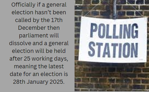
The latest a government can call a general election is the fifth anniversary of the first session of the current parliament. But the Prime Minister can call an election any time within that five year period. 25 working days are then allowed for an election campaign to take place before the election is held.

General Election: will the recent boundary changes have an impact?

It has been just over four years since the last general election was held in December 2019, and on 17th December 2024 it will have been five years since parliament sat for the very first time. This means that the UK is due a general election within the next year.

The image is split into two sections. On the left, there is a text that reads:
"Officially if a general election hasn’t been called by the 17th December then parliament will dissolve and a general election will be held after 25 working days, meaning the latest date for an election is 28th January 2025."
On the right, there is a photo of a sign that says "POLLING STATION" in bold, capital letters, attached to a brick wall.

Currently Labour is leading in the opinion polls, but with recent boundary changes the results of an election could be impacted.

The image is a line graph titled "Headline voting intention: Since the 2015 General Election." It shows the percentage of how people would vote if there were an election tomorrow, tracking from November 2015 to January 2024. The graph has two lines, one for Labour (in red) and one for Conservative (in blue), with shaded areas representing the confidence interval for each party's line.
Key events are marked on the timeline with vertical dashed lines and labels:
- Corbyn elected (Sept 15)
- May as PM (July 16)
- Johnson as PM (July 19)
- Starmer elected (Apr 20)
- Truss as PM (Sept 22)
- Sunak as PM (Oct 22)
- General Election (no specific date indicated)
As of January 2024, the Labour party is at 49% and the Conservative party is at 27%.
The bottom of the image includes a note about the base of 8,000 British adults 18+, changes in methodology, and the source of the data, Ipsos Political Monitor.
Photo from Ipsos

Boundary changes are intended to reflect the population so that each constituency has an electorate between 69,724 and 77,062. The last boundary changes were made in 2010 with reviews held in 2013 and 2018 but due to opposition no changes were made. Boundary reviews now need to take place every eight years.

Recent changes made by Boundary Commission of England have seen Wales lose 8 seats, Scotland lost 2 seats, England gain 10 seats and Northern Ireland retaining all their seats.

So how could these changes impact an election?

By changing the boundaries, it leaves marginal seats vulnerable, whilst increasing the majority in safe seats. There are currently 67 marginal seats in the UK, these are seats that have been won by a margin of 5% or less.

The lowest majority seats belong to Fermanagh and South Tyrone in Northern Ireland with only 57 votes between Sinn Fein and Ulster Unionist Party. With the recent boundary changes this constituency are taking 4.1% of Newry and Armagh, and 0.9% of Mid Ulster. This could potentially make this constituency a safer seat for Sinn Fein as the boundary changes take in constituencies with majorities over 9,000 votes.

The image is a map titled "Final Recommendations: Fermanagh and South Tyrone." It shows a detailed outline of the region with various towns and areas marked, such as Enniskillen, Lisnaskea, and Dungannon. The map has a key indicating that solid lines represent "Final Recommendations" and dashed lines represent "Ward Boundaries (2012)." There is a scale at the bottom indicating distances in miles, and a list of ward names with corresponding numbers from 1 to 6, including Ballysaggart and Roscorry. The logos for Ordnance Survey and Land & Property Services are at the bottom right. There is a disclaimer about copyright and database rights from 2013.
image from Northern Ireland Boundary Commissions

Scotland has been reduced from 59 to 57 seats with the Highlands reducing from 3 to 2 seats, Allan Faulds who runs Ballot Box Scotland believes the “boundary changes probably won’t impact voting patterns” adding that Scotland has “already seen strong tactical voting that has made most constituencies into clear “the SNP versus one other party” contest.”

The image displays two maps of the United Kingdom, side by side, titled "UK Parliament Boundary Review: Final Recommendations." The left map is labeled "Current Boundaries Overlaid" and the right map is labeled "Revised Proposals Overlaid." Both maps are color-coded to differentiate various parliamentary constituencies, but the colors themselves do not signify anything other than to distinguish the areas. The maps show the changes in constituency boundaries between the current and proposed revisions. There is a disclaimer at the bottom stating, "Colours don't mean anything, they are just for highlighting the constituencies." Additionally, there is a copyright notice that reads, "Contains OS data © Crown copyright and database right 2023."
image from Ballot Box Source: Rallings & Thrasher, Professor David Denver (Scotland), Nicholas Whyte (NI) for Sky News, PA, BBC News and ITV News”.

Wales has decreased by eight seats, two constituencies in Wales are minority seats. One is Alyn and Deeside with 213 seats separating Labour and the Conservatives. The other is Delyn within the county of Clwyd which has a majority of 865 votes. Both constituencies have no changes to their boundaries.

In England the scale of change is large, out of the 533 constituencies only 55 will be unchanged. Seats in the North East, North West and West Midlands have decreased, while those in the East of England, South East, South West and London have increased.

Cheltenham has undergone boundary changes in all but two of the wards. Rowana Hay leader of Cheltenham Borough Council stated in a press release “I’m pleased that the boundary changes put forward to our members were taken into account. These ward changes will better reflect the increase in our population and growing communities.” Cheltenham is also a marginal seat with only 981 votes between the Conservatives and Liberal Democrats. The boundary changes have seen Cheltenham reduced with some of the area going to Tewkesbury, potentially increasing the safe hold the Conservatives have in Tewksbury, but this means that Cheltenham could change to a Liberal Democrat seat.

The image is a map titled "Boundary Commission for England - Final Recommendations for the South West Region" specifically showing the Cheltenham Borough Constituency with an electorate of 75,292. The map outlines the constituency boundary in green, which encloses a detailed street map of the area. There are also boundaries for local authorities and wards within the constituency, marked with dotted lines. On the right side of the image, there is a legend explaining the symbols used on the map:
- Green solid line represents the Constituency
- Black dotted line represents Local Authorities
- Black dashed line represents Wards
Additionally, there is a list of the wards within the constituency:
1. All Saints
2. Battledown
3. Benhall and the Reddings
4. Charlton Kings
5. Charlton Park
6. College
7. Hesters Way
8. Lansdown
9. Leckhampton
10. Oakley
11. Park
12. Pittville
13. St. Mark's
14. St. Paul's
15. St. Peter's
16. Up Hatherley
17. Warden Hill
The map also includes a scale bar at the bottom indicating distances in kilometers (0, 0.4, 0.8 km) and a north-pointing arrow for orientation.
image from Boundary Commissions from England

On the other hand, Dagenham and Rainham have a 12% increase to their constituency; gaining 9.1% from barking and 2.9% from Hornchurch and Upminster. Currently Dagenham and Rainham is a Labour seat but with only 293 votes separating Labour from the Conservatives. Barking is also a current Labour hold with a much higher majority of around 15,000 which could mean an increase in Labour votes. However Hornchurch and Upminster is a Conservative hold with a majority of around 23,000. This is definitely a constituency to look out for when the next election comes!

The image is a map showing the final recommendations for the London Region Dagenham and Rainham Borough Constituency with an electorate of 73,627. The map is detailed with street-level data, and the constituency boundary is outlined in bold green. The boundary encompasses various labeled sections, likely representing different wards or areas within the constituency. There are numbers from 1 to 11 scattered across the map, each corresponding to a ward listed below the map:
1. Eastbrook
2. Elm Park
3. Hacton (Part)
4. Heath
5. Rainham and Wennington
6. River
7. South Hornchurch
8. St. Andrew's (Part)
9. Valence
10. Village
11. Whalebone
The map also shows the surrounding local authorities and wards with lighter lines. There is a compass indicating north at the top right corner and a scale at the bottom right for distance measurement. The title and information are at the top, and the bottom of the image has the title "Dagenham and Rainham Borough Constituency" in bold letters.
Image from Boundary Commissions for England

There are many more constituencies that have had boundary changes, you can see if you have changed constituencies on the House of Commons website.

Historically boundary changes have favoured the Conservatives and looking at the publication of estimates for if the 2019 election had been held with the new constituencies, we can see that the Conservatives would have had 372 seats rather than 365, with Labour getting 201, Liberal Democrats getting 8, Plaid Cymru getting 2 and the SNP, Greens and Northern Ireland votes staying the same.

The image shows two color-coded maps of the United Kingdom, side by side, representing different years, 2019 and 2024.
On the left, the 2019 map:
- The majority of England is blue.
- Scotland is yellow.
- Wales has a mix of green and red areas.
- There are small patches of red scattered throughout England.
On the right, the 2024 map:
- England shows a more mixed pattern with blue, red, and a few areas of green.
- Scotland remains predominantly yellow with some red areas.
- Wales has both green and red areas, similar to the 2019 map but with a slight increase in red areas.
- Northern Ireland is visible in green on both maps.
The blue, yellow, red, and green colors likely represent different political parties or voting patterns, but without more context, the specific meaning cannot be determined.
image from The Telegraph

If the boundary changes had an impact the most likely place we will see a change is in England, but based on recent opinion polls Britain could see a shift in its politics.

The truth is we won’t know for certain until 10pm on Election Day.